Tuesday, November 10, 2015

Quick Built 20 year Layered Garden

Just finished a small layered garden.  Originally I planned it to be 200 SQFT but scaled it down to 180 once I plotted out the pegs.  In this one I used 100% of materials I had on hand, most used/recycled so there was zero additional cost except for labor. I rushed to build it as the fall material availability is starting to decline as most of the leaves have fallen and gardens cleaned up.  We still the archaic term for these organic materials as 'waste', I see it as a secondary harvest, leaves, lawn clippings, shrub and tree trimmings, annual flowers.

In this one we will use secondary food products:  peelings, plant leftovers, egg shells, coffee grounds, rinds. At a pound a day times 365 days, the nitrogen factor should be solved even if most of the material, dead leaves are carbon.   Cut and drive in 4'- 2"x4" stakes leaving 2' above grade:


Wife says OK but make it pretty.
  
Added 2' high wire fencing and at the base of the perimeter, 6" planks of old fence planks to I can keep the perimeter trimmed


Inspired by Hugelkultur, the first layer was thicker wood branches, directly on the soil


Next began layering with other second harvest material: leaves, trimming, discarded plant material from the neighborhood. 

Final step is to fill it up with second harvest material this week and let it cook down over the winter until spring planting if enough of the organics have broke down by then.


Aviaticus Clouds are forming in the encroaching boundary sheet, rain on the way so the moisture will accelerated the decomposition.

I expect the structure to last at least 20 years and if ever abandoned the soil will be left improved.

We daily had added lots of organic material, potato peelings, egg shells, coffee grounds.... After cooking down a couple months I added another layer before the snow:

First a load of cardboard from a local company, the cardboard may suppress unwanted plant growth:


Then I intercepted another load of wet leaves from the neighborhood that was destined for the landfill:


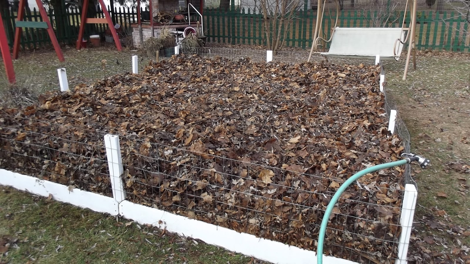
The rest of the winter we will continue to top this off with organic materials.

Thursday, August 27, 2015

Building Natural Looking Bird Nesting Boxes, Birds Love Them!

Locally I've been able to purchase 8' cedar logs with 6-8" diameters from $3-$6 and developed a quick way to build several bird nesting boxes out of each log. First I make a box out of the top 12" of the log using the procedure below and place that nest on an existing fence post.  The remaining 7' is made into an ideal natural looking nest log.  My tools are limited so someone with more or less tools could easily improve/adapt on the plan:

Slice off a 1 1/2"-2" slab for the cover

 Mark for a 4" nesting cavity

 Label the slabs before cutting

 Cut 8-10"


 Leave a 1" base on the log when cutting off the side slabs so the slabs can be re-assembled and re-attached to the log.
 Once the cavity block is cut away, re-assemble the sides with deck or drywall screws


 Cut or drill a 1 1/2" hole, sand edges

 Attach the cover with screws or, a hinge if you intend to monitor the nest


 Set up

This one we set up late in the breeding season but it was quickly found by Eastern Bluebirds and they had a successful nest of 4-5 fledglings.

Monday, July 13, 2015

Clouded Memories

Memories fade. Since I have been bird watching and nest monitoring I've realized just how fast. It is not common to come across an original memory that is 40-50 years old as most memories that age may be memories of a memory. Recently  I recalled a memory from over 50 years ago, that I had not thought of since it happened.  I don't know exactly what stimulated this but it was related to the aviaticus clouds we see often in this modern sky.

I've heard it a few times, someone who was a sky watcher back in the '60's say, there were no persistent aviation clouds back then...no, there were, we just do not remember, we do not remember because they were not aviation clouds to the young observer, just clouds, linear clouds.

The sky was however different in those days.  The sunsets were awesome, blazing with colors, reds, yellows and oranges that morphed purple before becoming gray.  It was my belief then, as a child, that God painted each sunset and I would marvel at the creative beauty and wished they would last. Sunset was a time of peace and the colors were a seal of the promise of another great day to come, the next day. By today's standards, even a bit by the standards of those days, we were poor, materialistically speaking.  But it was my belief, we lived in the greatest state of the greatest country in the world and at sunset I would say to myself and my Creator, how could I be so fortunate?  Even food took a lower priority to that. The air was thick with life, when there was food, at times it felt like it was a bother to have to stop to eat.

In 1973, I saw my last awesome sunset. it was fall, it was during the Israeli-Arab War and looking out the barrack's window at Fort Dix, it appeared half the sky was lit with blazing colors and beams of light. I never saw another one even remotely close since and the youthful feeling of peace at sunset has never returned.  Well almost true. Several months ago I opened my mind to the idea again that God created the beautiful sunsets and though not coming close to the startling beauty of those sunsets of the 1960's, that early evening I saw the greatest sunset since those days, fairly glorious and large but still lacking those brilliant colors. So my point, the sky was different back then.

So this week I recalled a linear cloud I had seen in my youth, never had I thought of it since until then. Not only had I recalled the sight in my mind but I recalled as if back to that moment that I had seen clouds like it many times before. It was just looking in the sky, not asking 'I wonder why that cloud is long?' but somehow knowing it was different, enough to remember it after 50+ years. Who would remember such a thing?  Can anyone look back 50 years and remember the shape of any particular cloud? I was like the others, we just did not have the aviation clouds back then. Wrong, we did, but we did not process them as man-made, they were clouds. nothing more and the thought never occurred that they were caused by jet exhaust.  Next: Why so many more now?

Friday, May 1, 2015

Contrail, Aviaticus Cloud Viewing Forecast Periodically Updated

Central Wisconsin Flyway Forecast and Summary 5/5/2015

The Central Wisconsin Flyway is right on the edge of a boundary line (sheet) with heavy clouds to the South and dry clear skies to the North so we should see some aviaticus (contrail) formations today unless the dryer air pushes south over the Flyway.  The Rapid Update Cycle Map is showing conditions for contrail formations favorable to the south, but it appears the cloud cover is too heavy to matter.


Central Wisconsin Flyway Forecast and Summary 5/2/2015

I was out of town most of day so it was interesting to view another flight pattern  producing mostly non-persistent aviaticus and a few lasting segments in a double-layered clouded sky, cumulus and light upper scattered sheets.

Back home toward dusk only whiffs were being laid and in this short video they can not be seen:


At the time of the video dry air was passing over the Flyway from the west shown as the dark swath on the moisture map:


Conditions should be good for aviaticus formation all day tomorrow ahead of Sunday evening's predicted thunderstorms.


Central Wisconsin Flyway Summary and Forecast 5/1/2015:  Yesterday began with a full morning of no trails, not a whiff or a pencil.  Just a sun-filled sky dotted with the summer-like white cumulus.  Then about 1 PM CT with some moister upper air, short non-persistent spits were forming from the afternoon east bound.  The aviaticus trails grew longer as the afternoon progressed indicating a boundary sheet was entering our Flyway preceding a thicker cloud bank.  By dusk persistent aviaticus continued forming and in the far west horizon a layer of white clouds could be seen creeping in.  In the morning thin sheets of upper clouds were still present and the Flyway was still marked with lateral aviaticus clouds holding together for example 15 minutes before dissipating, and heavier, broken patches of high natural clouds followed.  The natural cloud bank may continue to thicken to where aviaticus will not be viewed this afternoon and it appears this bank will pass over and the trailing edge may be a boundary sheet where trails will form until dryer air follows this.

At 1:10 PM CT yesterday the airliners started to leave short trails, here is a video of 4 flights that passed overhead 37,000-40,000'. Video at 24X speed (Please excuse the poor quality of this clip, I'm just starting to work with a screen recorder):


By 6:30 PM CT Skies had many persistent segments in the boundary sheet as a cloud layer approaches:


http://theorioninitiative2.blogspot.com/2015/04/forecasting-day-long-aviaticus-cloud.html

Tuesday, April 28, 2015

Forecasting A Day Long Aviaticus Cloud Event over the Central Wisconsin Flyway

4/28/2015 0700 CT: It appears by the indicators we should have good aviaticus cloud production by this afternoon. An air mass is moving in from the west-northwest and it appears a distinct boundary line (sheet) will precede this.

Update:  The indicators were correct.  NASA's Rapid Update Cycle  map based on the old Appleman Chart however did not show the likelihood of contrail formations.  I can say this is evidence that human analysis will be necessary for forecasting aviaticus events as the RUC model does not take into consideration present/past meteorological and flight tracking patterns.


The Boundary Sheet precedes this cloud mass, the 'dash' within the circle is our flight corridor, infrared map site:


Moisture Map at 7:15AM shows a trace of the Boundary Sheet pushing out the dry air (dark band). At 7:30AM when the first west bound aircraft passed over the green dash, they left segmented persistent aviaticus clouds (water vapor site):


First trails from west-bounds at 7:30AM (Looking East):


Here is the RUC map at that time indicating no upper air conditions for contrail formations in our flyway (White Dash):


In early afternoon RUC indicated favorable conditions: 


At that time both infrared and moisture maps indicated the boundary sheet was right over the flyway as indicated in these screen shots: Maps from NOAA Site


At that time I needed to drive north of our Flyway 7 miles and this is what the cloud cover looked like at the time the above maps were displayed:

Looking North away from the Flyway, note generally natural cirrus:


Looking south into the Flyway with both natural and aviaticus clouds:


As of 5:00PM CT persistent spreading aviaticus clouds are still being formed. Here is a remnant segment from a nice spreading trail:


Typically these trails from the northwest transports are Asian flights to Chicago.  Using the flightradar24 playback, my best guess from when the trail was laid and figuring drift of the formation, this was the aircraft that laid the above aviaticus trail:


At 6:00PM CT a parade of aircraft in quick succession passed through the Flyway leaving some nice trails within the thin aviaticus cirrostratus cloud layer that had developed or had mixed with the natural clouds:


During the night the cloud mass(es) passed through being coat-tailed by mid-altitude clouds and not even a whiff or pencil of short term aviaticus. 

http://theorioninitiative2.blogspot.com/2015/04/forecasting-day-long-aviaticus-cloud.html

Thursday, April 23, 2015

All Clear on the Central Flyway Today, here is why not a single contrail is to be seen:

Fabulous cool clear blue day with dry upper air and not a spit of an aviaticus trail or hint of a drifting cirrus to be seen.  Where are the aircraft? They can be heard flying over but only with a sharp eye or binoculars can they be spotted today.  They are all laying out sub-visual aerotrails of water vapor, cloud condensing nuclei such as soot.  The cloud mass exited over night and during that time the boundary line passed over the Central Wisconsin Flyway, even if conditions were right for contrail formation not that many flights were scheduled then.

Here are some photos that demonstrate why the aviaticus clouds (contrails) are not forming today:

A wide swath of dry air is covering most of the state of Wisconsin so exhaust vapor is not condensing on the cloud condensing nuclei spewed by the aircraft. Maps of Water Vapor &  Infrared from NOAA Site.


Below is a map of cloud cover with a line drawn to show the approximate corridor of jet traffic


We have a forecast for light rain Friday night 4.24.2015 so the best chance of an aviaticus event would be Friday when a moister boundary line passes through the Flyway from the Northwest prior to overcast.

Update:  Only light non-persistent aviaticus continued through Friday until the overcast covered the view. But as the overcast broke a bit Saturday morning remnants of persistent trails could be seen but no new trails could be seen in the broken cloud cover the rest of the day. 4.25.2015


4/26/2015  0600 CT:  This morning a huge mass of clear day air swung in from the north but it appears a blurred boundary line is following with a bit more moisture so by the time air traffic begins in another hour the transports should sport only short whiffs, if any at all.  The rapid update cycle map does show possible contrail forming conditions in the eastern segment of this flyway but I won't know until the Sunday morning traffic begins if those conditions remain or pushed south and aviaticus actually form.

Note small blue circle within the large white circle near Green Bay on the east side of our east/west Flyway on the Rapid Update Cycle Map:


4/27/2015 1800 CT: The same weather pattern continues. Short to no contrails, none persistent from morning until noon.  Interesting water vapor pattern.  Again the dry area dominated the flyway as moister air pushed in from the east and surface winds were from the north, the dry air (browns and blacks) became faintly stratified with bands of moister air (white) as seen on this map (water vapor site)


At this time loose bands of natural cirrus clouds were moving through.  By noon a few segments of persistent aviaticus clouds could be seen as aircraft would traverse these areas.  By later afternoon the stratification was gone. Then that air mass had pushed over the flyway as seen in the map with more moister air (white area) replacing it. Infrared Map Site


Some trails became longer but none would persist and a few depending on altitude left short segments as they passed through the cooler moister air:


This photo is looking east from the east/west Flyway. Note a persistent segment of aviaticus clouds.  The natural cirrus may be at or near the same altitude as the aviaticus segment.  These cirrus clouds did not show up on the infrared map but I'm associating these natural and aviaticus cirrus with the bands or lighter areas of moister air.


4/28/2015 0700 CT: It appears by the indicators we should have good aviaticus cloud production by this afternoon. An air mass is moving in from the west-northwest and it appears a distinct boundary line (sheet) will precede this.

http://theorioninitiative2.blogspot.com/2015/04/all-clear-on-central-flyway-today-here.html

Sunday, April 19, 2015

Go Seven Miles North, then Turn Straight up for Another Seven Miles

A sky full of of aviaticus clouds is exciting, the same sky without aviaticus clouds/contrails is beautifully relaxing.  During this weekend's aviaticus events I drove north just 7 miles from the edge of central Wisconsin's long used east west flight corridor. Just a short distance, the equivalent between me and the typical overhead jet and everything changes. The area goes from ag land to forest, the sky goes from cirrus and aviaticus clouds to cirrus and blue. From an open area where you can see the weather to the south and north, to just being able to see the weather overhead because my destination is surround by trees. It is nice for a change to look up and not see an aircraft streaking out a plum, where I automatically go into analysis mode estimating altitude, width of the trail, watching to see if the trail dissipates or becomes permanent or if it will spread, if so. which direction it drifts. Curious, I might check the flight software to see its altitude, type of aircraft, speed and destination, perhaps seeing another aircraft tracking in the same direction with only a needle-like short-lived trail and then I feel the need to quickly verify that the altitudes are different as the vertical depth of the ice saturated air in which a permanent aviaticus has formed is quite thin, perhaps a 1000'. Yep, it was nice just a few miles north of the flyway, looking up and seeing none of this and not being able to see what was going on in the south along the flyway because the trees block that view. I just go back to my tasks, not distracted by what has now become an unfamiliar spring Sky, the sky of my distant childhood. The only thought that may slip into my mind while I am north, are the clouds I am seeing natural, aviaticus or a hybrid of the two?  But without the obvious linear shape, it is not possible to know so that thought dissipates faster than a short trail in dry/warm air and I go about enjoying the view.

The original problem posed by contrails were for military reasons.  Now the funded sciences are trying to find a solution because of the climate changing possibilities of aviaticus clouds, warming, cooling, hydrology cycle disruption or even if there is a problem, is it significant?  Aesthetics are hardly mentioned in the funded studies that I've read. Nevertheless if they successfully find a solution to this very complex residual effect of air transport, the aesthetics will follow, the naturally beautiful sky literally will follow.  

Researchers are pursuing the solutions for contrail elimination, but each contrail solution like pharmaceuticals have challenging side effects.  Will more efficient engines to reduce the soot nuclei produce greater heat or possibly more water vapor or CO2?  Flying around ice saturated air could cost more fuel, lengthen flight time, place more stress on crews, passengers and air controllers. Changing traditional flight altitude to the tropopause or lower stratosphere where the air is dryer and contrails are unlikely to form. But then the concern is for ozone depletion from the chemical emissions. Ideally short of reducing air travel, since the ice saturation sheets are thin, if they can be detected these sheets with precision, altitude adjustments of just a few thousand feet during each flight to avoid those areas could reduce aviaticus clouds to a great extent. Having at the same time more efficient engines and fuels that produce less soot nuclei would still be important. First clouds can still be formed by the sub-visual aerotrails of soot particles well after the aircraft has passed as the particles contact more humid air. Still little is known of the effects of millions of aerotrails even if no contrails are formed. Perhaps there are no negative effects,  perhaps the accumulation of these particles are having an effect on climate or health we do not yet understand or that the public is aware of.


For more on this subject please read Ulrich Schumann's 2005 published paper:


Extended Aviaticus Cloud Forecast:  By Wednesday 4.22.2015 the cloud cover should begin to break and a dryer air mass should move in. Earlier Thursday the clouds should be clearing out and during this period contrails should form but decrease to short-lived whiffs by late afternoon Thursday or Friday morning.

http://theorioninitiative2.blogspot.com/2015/04/go-seven-miles-north-then-turn-straight.html

Saturday, April 18, 2015

Short Aviaticus Event This Morning Along the Central Wisconsin Flyway


A wide band of high clouds on the edge of a boundary sheet has moved through the center of Wisconsin this morning, preceding  heavier clouds from the southwest, a pattern repeated in the last 5-6 days.  The difference this time is that rain is predicted so as this first wave of pre-precipitation  mass moves in, what  aviaticus pattern will follow?  It is mid-morning so air traffic has slowed and so I'm not sure if it is a hiatus in the traffic or if a band of dryer/warmer air is passing over but the water vapor map indicates it is band of dry air.  However cirrus are still moving in from the Southwest but I can not tell if they are natural or aviaticus.  

My prediction is that the persistent trails will cease during this present period of dryer upper air and just before the thicker clouds move in,  they will again form.  Any sky watcher north in northern Wisconsin would be thinking that same thing as our aviaticus clouds drift north.  Here are directional shots of the event.

Early this morning, looking east where the aircraft originate:


Two views looking south into the flyway (note white Horizon):


Looking North out of the Flyway to where the Aviaticus are drifting (note clear horizon):


http://theorioninitiative2.blogspot.com/2015/04/massive-day-long-contrail-event-of.html