Showing posts with label aviation. Show all posts

Saturday, April 18, 2015

Short Aviaticus Event This Morning Along the Central Wisconsin Flyway


A wide band of high clouds on the edge of a boundary sheet has moved through the center of Wisconsin this morning, preceding  heavier clouds from the southwest, a pattern repeated in the last 5-6 days.  The difference this time is that rain is predicted so as this first wave of pre-precipitation  mass moves in, what  aviaticus pattern will follow?  It is mid-morning so air traffic has slowed and so I'm not sure if it is a hiatus in the traffic or if a band of dryer/warmer air is passing over but the water vapor map indicates it is band of dry air.  However cirrus are still moving in from the Southwest but I can not tell if they are natural or aviaticus.  

My prediction is that the persistent trails will cease during this present period of dryer upper air and just before the thicker clouds move in,  they will again form.  Any sky watcher north in northern Wisconsin would be thinking that same thing as our aviaticus clouds drift north.  Here are directional shots of the event.

Early this morning, looking east where the aircraft originate:


Two views looking south into the flyway (note white Horizon):


Looking North out of the Flyway to where the Aviaticus are drifting (note clear horizon):


http://theorioninitiative2.blogspot.com/2015/04/massive-day-long-contrail-event-of.html

Wednesday, April 15, 2015

It is Time for Professional Meteorologists to Step Up & Begin Forecasting the Big White Elephant in the Sky

Over the last last 4 months I have attempted to forecast contrail events for Central Wisconsin. Untrained in meteorology and particularly in upper atmospheric science, I have had to rely on ground based observations of weather and air traffic patterns and national weather maps and local weather forecasts.  Here are a few things I have learned or observed:


  1. All combustion aircraft leave a persistent trail, invisible from the ground, called an aerosol trail, aerotrail for short.
  2. The aerotrails are composed of cloud condensation nuclei. (CCN) These are basically small particles of soot that may form into water droplets or ice crystals depending on the temperature of the air.
  3. All combustion aircraft add water vapor to the atmosphere.
  4. The lengthening or shortening of contrails (cirrus aviaticus) indicates areas of temperature or moisture changes in the upper atmosphere or both.
  5. When contrails of short duration begin to lengthen, going to needle size, to pencil, to fishing pole, expect persistent contrails to begin forming. 
  6. As drier or warmer upper air masses move into flyway areas expect to see the contrails become shorter in length and duration or not appear altogether.
  7. When natural cirrus clouds move through a flyway, contrails will more likely be visible.
  8. Multiple persistent trails may spread to form milky sheet clouds. I call these clouds cirrostratus aviaticus.
  9. Persistent contrails most likely form on either side of moisture boundary lines, sometimes called dry lines. These boundary lines can be wide and I call them boundary sheets.
  10. As the boundary sheets drift within the flyway additional aircraft pass though them laying more invisible aerotrails and moisture making the cirrostratus aviaticus denser in appearance.
  11. If the drift is in the direction of the predominant flyway traffic the ice crystal saturation can lead to the viewing of or at least enhance sun dog halos.
  12. If  the persistent cirrus aviaticus (contrails) or cirrostratus aviaticus (milky sheets) drift outside the flyway, they tend to thin or dissipate.  With the lack of traffic no more man-made nuclei is added.
  13. So far, from identifying the aircraft using flight tracking software,  I have not been able to identity any deliberate laying of chemtrails (chemical trails)
  14. All the phenomenon I have observed so far has been from regular commercial airline traffic flying between 30,000-40,000'.
Today we have heavy persistent cirrus aviaticus clouds forming and morphing into cirrostratus aviaticus within the Central Wisconsin Flyway.

http://theorioninitiative2.blogspot.com/2015/04/it-is-time-for-professional.html

Sunday, April 12, 2015

Why do Contrails (cirrus aviaticus) form into milky opaque sheets (cirrostratus aviaticus)?

Never in history have we had so many airline flights.  37,000,000 scheduled flights last year and who knows how many unscheduled?  Aircraft manufactures are swamped with orders.  Contrails (aviaticus clouds) visible from the ground are common but only represent a fraction of the invisible aerosol trails (aerotrail) left by all combustion aircraft composed of a mix of small nuclei of combustion residue called Cloud Condensation Nuclei (CCN) .  If we could somehow see each aerotrail  as we can contrails our entire view of the sky would change especially along heavily used flyways.  There we would see hundreds of persistent spreading trails and multiple layers of milky sheets everyday.

But we only see high altitude persistent contrails and milky sheets at certain times when meteorological conditions are right.

Imagine a full blue out day along a flyway, you have the aircraft but not a whiff or needle of a contrail is to be seen and it is difficult to spot the passing aircraft that you can hear.  At this time they are all laying a wide persistent aerotrail and if they were visible the sky would already be heavily streaked with other trails that had drifted into your area from flights outside your viewing area.  But back to what you are actually seeing. Later,  as the day progressed the high altitude  airliners begin  sporting short non-persistent trails and several hours later longer trails. By after noon you see segments of persistent contrails in the far horizon starting to drift into you area.  Several hours later they are closer and still intact and now some of the airliners in your flyway begin to spew thick persistent trails and even the approaching aviaticus clouds now look like natural cirrus in a lighter blue, whitish sky.  Shortly these milky clouds are covering your flyway and still the passing jets are laying thick persistent trails. From the ground view at a fixed point it appears like these aircraft are deliberately spraying some type of chemical to cause this change.  But you track the aircraft and they are regularly scheduled flights from all over the country (world in some cases) so what is going on? 


What you have observed is a high altitude boundary line passing over your area.  On one side of the line the upper atmosphere was relatively warm and dry and or the other side of the boundary line it is colder and wetter.  But it is not really a line, that is a thin line, but the line is more like a wide sheet.  Imagine  the a line in the sky that is 10-20 miles wide so it may be better to call this a boundary sheet.  This boundary sheet was first visible to you when you began to see the contrail segments drifting toward you from a far horizon.  As the leading edge of this sheet began to approach your area the atmospheric conditions began to slowly change from dry/warm to moist/cooler and the contrails in your flyway began appear and then become longer.  The closer this boundary sheet came the longer your trails form. At the same time that boundary sheet is being intersected with more and more aerotrails that are forming more visible spreading persistent contrails and that section of sky is taking on a lighter shade of blue and becoming increasingly milky white.  The moist air coming into contact with the dry air causes natural cirrus clouds to form into cirrostratus clouds and the same process is taking place with the cirrus aviaticus clouds.  By the time the boundary sheet reaches your overhead flyway the sky is already milky white.  Additional aircraft passed through this sheet during its slow progress to your area while it was reforming into a stratus from contact with the warmer air.   Once the sheet passes over and out of your area it may have been followed by natural thicker clouds as the original boundary sheet was the atmosphere that precede other natural cloud formations.  Or it may be followed by blue skies and a shrinking or disappearance of the contrails.  I have viewed many of the former but here is an example of the latter:

At the time of the event this is the a screen shot of the infrared loop: 


A screen shot of sky cover loop shows no cloud cover: (From 

From the moisture loop a swath of dry air is swiping across Wisconsin from the Southwest: Map from NOAA site


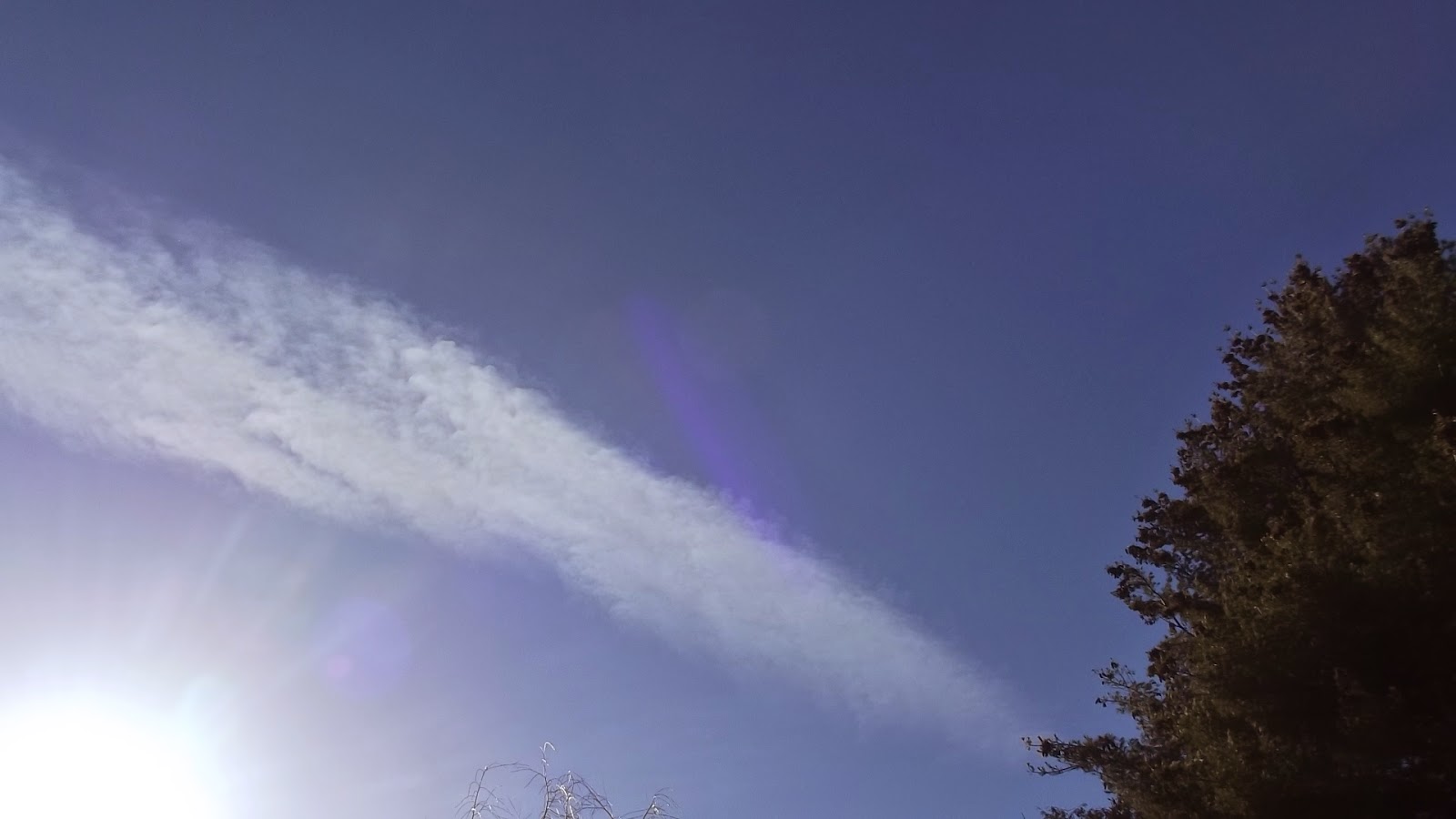
As the boundary line (sheet) moves in to my Central Wisconsin flyway, contrails begin to lengthen and segments of persistent trails can be seen in the the southwest.


As the boundary sheet approaches more jet traffic add additional exhaust nuclei to the sheet and the milky skies form. Photo of approaching moist air:


When the sheet passed between me and the sun I thought it was going to be thick enough to form a sun dog but it did not and after the sheet passed, an hour or two the boundary sheet and original persistent contrails could still be seen probably past Green Bay and over Lake Michigan.  At this time the contrails in my viewing flyway had resumed to whiffs and needles in a full blown blue out of sky.

Afternoon Forecast:  Since dawn we have had clear skies with not a whiff of one trail appearing along the Flyway.  By 2PM CT we could have some contrail forming,  We do have a nice swath of upper atmosphere dry air right along the Flyway but it appears that will push Northeast and the blue skies could be replaced by an wide swath of upper clouds trailing alongside a approaching heavier cloud mass.  I would expect at minimum lengthening contrails as this brushes overhead and some accumulating persistent vestiges that may form higher milky cirrostratus aviaticus.

Update: By 2:00 PM CT those edge clouds came rolling through as cirrocumulus, lower altitude than the cirrus and only one short trail was observed.  By 4 PM a few persistent segments drifted into the flyway and by 6 PM several long lasting trails (5-10 minutes) were laid overhead afterwards it reverted back to needles and whiffs through sunset.

http://theorioninitiative2.blogspot.com/2015/04/why-do-contrails-cirrus-aviaticus-form.html

Sunday, April 5, 2015

Aerotrails: Why Some Contrails Last Longer than Others?

Anyone who studies and writes about aircraft clouds realizes there is a need for a new vocabulary for contrail studies and descriptions.  Roland Nunez from Embry-Riddle Aeronautical University in an interesting paper that was published in 2014, writes about this.  He also used the term 'areotrails', a contraction of aerosol trails, basically the unseen soot pollutants in aircraft exhaust. These invisible trails may explain why some persistent trail clouds are larger, spread wider or last longer than other persistent aviaticus trails. All jets leave aerotrails and there were over 37,000,000 flights scheduled last year, 37 million invisible areotrails! This does not include private, scientific and military flights.

When aviaticus (aircraft) clouds are formed, are the nuclei of which the water vapor attach to and form ice crystals natural atmospheric nuclei such as volcanic particles?  Or are they from the soot particles?  A combination of both?  I would guess the combination of both. In a cold high humidity area of the upper atmosphere that is also saturated with natural nuclei, wouldn't the extra nuclei introduced from the jet exhaust cause the formation of more ice crystals and thus a more robust cloud?  Then as the trail clouds drift and mix into even higher humidity and colder areas or areas with higher natural nuclei, couldn't the clouds continue to expand?  Is it possible some of the cirrus clouds we see and assume are natural, are formed when invisible aerotrails drift into and mix with atmosphere that is more conducive for cirrus formation but lacking natural nuclei?  Could the mix of natural and aircraft exhaust nuclei explain the milky clouds (cirrostratus aviaticus) during heavy contrail events?

No contrail forecast for central Wisconsin today.  Even though it did not look like the conditions were right for aviaticus formations, the weather forecast was for cloud cover anyway. We did start out with a nice AM 'blue out', with not one whiff or needle of trail.  But just before the cloud front moved in a few segments of persistent aviaticus trails were seen.

http://theorioninitiative2.blogspot.com/2015/04/aerotrails-clue-to-why-some-contrails.html

Saturday, April 4, 2015

Contrail Forecast: Blue 'n Dry at the Surface and Upper Atmosphere for Central Wisconsin Today

No Short or Persistent Aviaticus Trails for today.  A great day for outdoor photography if you want to avoid man-made clouds in the background.

Update 4/5/2015:  No short whiffs or persistent clouds (cirrus aviaticus) formed yesterday, no milky sheets (cirrostratus aviaticus) or remnant segments (cirrus aviaticus) drifted into the area. 

Thursday, April 2, 2015

Today's Aviaticus (Aircraft Clouds) Forecast For our Central Wisconsin Flyway


Gray matter, talking clouds here,  not to be confused with the theoretical and ever elusive 'Dark Matter'  of the universe, will be moving out of Central Wisconsin starting in early afternoon.  We should have some thinning residual clouds coat tailing those exiting thick gray clouds  and that may be the best time for contrail formations and viewing.  Later we have a section of low vapor air crossing our area and another possible total blue out where not even whiffs and needles of trails will be visible.  Cirrostratus aviaticus clouds (milky thin cirrus layers) are not likely.  


We will have good east to west high altitude air traffic at that time during the afternoon so it will be interesting to watch the trail development or lack of development during the transitions.

End of Day Update: 

About noon the the gray clouds shifted out of the area and were tailed by high thin, but not transparent clouds that revealed the remnant of jets from the east west corridor as forecasted. The sun dog indicates the ice crystals and a fine medium for aviaticus formation:


Further west and approaching was the clear less humid atmosphere.  Here the first break in this long cloud event a west bound aircraft laying a visible trail. This cirrus aviaticus dissolves as it passes through the blue zone, then appears again as it crosses over a thicker remnant of the cloud front:


The rest of the day was a tangled mix of areas of cirrus and clear sky allowing the formation short trails and a few persistent trail. Here a segments drifts by. No cirrostratus aviaticus formed all afternoon:


http://theorioninitiative2.blogspot.com/2015/04/todays-aviaticus-aircraft-clouds.html

Wednesday, April 1, 2015

Aviaticus Pencils in the Sky Grow to Cane Poles

This morning in the west to east fly lane short aviaticus trails were being painted in the partly clouding skies. As more clouds moved in the contrails grew from pencil size (if you were to hold a pencil over your head) to half the viewing hemisphere. All dissipating quickly and then overcast ruled and goodbye sunshine with the increasing cloud cover that moved in.  Two short persistent segments could be seen in the south prior to cloud cover.  Perhaps some broken clearing this afternoon and upper atmosphere weather may bring about another viewing event before sunset.

UPDATE:  The cloud cover passed in early afternoon and the traffic began stroking out the elongated trails.  But mid after noon with heavy traffic along the east west flyway the cirrus aviaticus became quite numerous.  As they began to slowly spread, cirrostratus aviaticus formed within the natural and very thin cirrostratus.  Nice show.

This Canadair CRJ left a persistent aviaticus that was still in view and fairly tight even after I confirmed the landing in Minneapolis. Map from Flightradar24


An east bound Boeing at 34000 and a west bound Canadair CRJ-200 at 31000 appeared to be heading for a collision on the iPad, still impressive in the photo:


http://theorioninitiative2.blogspot.com/2015/04/aviaticus-pencils-in-sky-grow-to-cane.html

Tuesday, March 31, 2015

Total Blue Out in Central Wisconsin Again

Not a spit, whiff or needle of aviaticus clouds this morning and just an occasional orphan-like clod of natural cloud straggling from the north ahead of the front. We have a nice wide swath of low moisture atmosphere overhead right now. Not looking good for a decent contrail event as the front may move through after sunset. Very little cirrus preceding this front either.

So eyes in the sky on Eagles, returning Sandhill Cranes and Canada Geese and the occasional glint of trailess jet.  

As summer approaches and the atmosphere warms there will be fewer opportunities to view outstanding aviaticus events like yesterday. 

Update:  Wrong! The northern front hooked in from the west and bought a nice looking cloud mix of cumulus with a sheeting cirrus covering. But no aviaticus to be seen:


Then a few short lived trails were spotted darting between the cloud openings:


This is the first Aviaticus cloud, created by a westbound, that persisted. It drifted south for quite awhile but still held a tight form:


Then a surprise first, in the east, a south bound flight from Constantinople Turkey ripped by at 600 mph: (From Flightradar24)


After passing it began to descend and left a segment of persistent cloud (barely seen in lower right below) as it was dropping to between 28-30000':


With all the upper wind and apparent fast movement, no cirrostratus aviaticus formed within my view.

Monday, March 30, 2015

Central Wisconsin Aviaticus Cloud (Contrail) Forecast 3.30.2015

Presently we are clear, blue and brilliant with  barely a whiff or a needle trail to be seen.  Many of the passing traffic this morning are labeled with "No Call Sign" on the ADS-B tracking system.  Later this afternoon areas of the upper atmosphere where natural cirrus may form, the jet traffic should be spitting out short non-persistent trails, these may increase and lengthen as the precipitation low moves in from the west but I don't think there is a great chance to view persistent trails prior to the incoming cloud cover. Map from NOAA site


UPDATE: Pre-front thin clouds moved in early and quickly only several hours after I posted the forecast and with it a half dozen or so persistent trails right at a time when I was too busy driving to track and analyze.


ABOVE FACING SOUTH One trail maker in this shot tracking east to west along the fly way appeared to make a 90 degree turn to the north out of this formation.  As it left the clouds it continued to leave a good trail:


ABOVE FACING WEST I couldn't locate this guy on the Flight Tracker site,  Shortly after this shot was taken the portion of this persistent trail in the photo outside the hazy cloud front began to segment and dissipate in drier or warmer air.  Enlarged this can be seen at the far right of the trail behind the tree branches.

As the cloud front thickened with a bit of uniformity, I shot this partial sun-dog with aviaticus trails:


No short trails at all as I forecasted, the sky went from no trails to persistent trails with the front moving in. 

Sunday, March 29, 2015

Learning to Forecast Persistent Contrail Events: Small Town Corp Execs did not like taking the Train

For 16 years I have been back to my home area of Clintonville, Wisconsin, USA. I couldn't wait to leave when I was 17. Blogging about contrail clouds or more specifically aviaticus formations forecasting, I think it is an odd hobby for me.  I'm not a meteorologist or a pilot or a writer but somehow I'm drawn to all three.

In 1942, My great grandfather at age 77, with all his sons at war, worked his farm alone. He got his hand caught in a hay baler and shortly died of lockjaw. The City of Clintonville, (population today still under 5000), where Four Wheel Drive (FWD) Corp was located, was actively pursing a site for a municipal airport. My great grand mother then sold the farm land to the City. The airport was built and Wisconsin Central Airlines was formed by the  execs from FWD. The execs had began their own commuting flight to Green Bay with one Waco Bi-Plane they had acquired by trading one of their company trucks.  They soon found out they could charge other people and thus the airline company was created.  In 1952 they changed its name to North Central Airlines and became a large regional carrier. In 1979 North Central Airlines went national.  They bought Southern Airways and changed their name to Republic Airlines and a year later acquired Hughes Airwest.  Six years later Northwest Airlines bought out Republic and then Northwest merged  with Delta and in 2010 the surviving name was Delta Airlines.   I am now located 14 miles north of the Clintonville and I happened to take notice of the large number of planes that fly over or near Clintonville.  I still do not know if this is a coincidence because of Clintonville's geographical location between Minneapolis, Chicago and Detroit or if it is just a common traditional flyway that has nor changed in 70 years even though there has not been commercial service to Clintonville in many decades.  Now if I turn to face north with my back to Clintonville, there is little traffic to see so I am located in a rural area, on the cusp of a flyway with a great visual view of the sky traffic and Aviaticus clouds the traffic creates.

As I am writing this Flight ACA6 Boeing 777 from Tokyo to Toronto passes over Clintonville, WI


North of Clintonville, Wisconsin there is not much air traffic to view as shown from the example screen shot below


Not only is the air traffic easily viewed and tracked from my location because I for the most part need only look south.  In addition. the prevailing weather almost always runs west to east.  This is why this is such a good area to observe aircraft and weather patterns in order to learn to forecast persistent contrail events. (PCE)

Friday, March 27, 2015

A Full Day of Spotless Blue Skies & Today's Aviaticus (Contrail) Forecast

Lots of air traffic today on our Fly Way but not a whiff or needle of contrail (aviaticus clouds) to be seen. I was up at Legend Lake in Menominee County for an hour and did see one commercial jet pass over overhead, a rare occurrence.  The sun was so bright that without the dead quite of this northern woods I may not even have seen or have heard it pass over.

Earlier just south of Legend Lake in Shawano, the radar showed the normal fly way traffic mostly from Minneapolis to eastern destinations and the many Eastern flights that pass by us heading west, the usual flights from Asia that crossed over or through Alaska before tracking southward to Chicago.  Yet not a whiff of aviaticus to be seen all day. Despite all this aircraft activity even the the small town noise of Shawano over-tones the purr of high altitude aircraft, making them difficult to to spot.

A shot of today's sky, all day Friday:)!


Tomorrow's Aviaticus Cloud Forecast

Trails developing only with a little luck late Saturday afternoon as snow is predicted that evening and if east/west air traffic will still be busy. The front should move in from the west and may be preceded by high altitude moist air. Aviation Trails should appear in my location looking south to Clintonville just before sunset.  Some could be light and unlikely to spread into cirrostratus aviaticus before dark.

We should have a clearing Monday and Tuesday and may then have the best day for Aviation trails, just before natural cirrus clouds appear.

UPDATE:  By 3:00 PM Saturday, a west bound flight. a McDonald Douglas MD 90 NY to Minneapolis passed overhead and then started to spit out intermittent dashings of needle thin aviaticus clouds which shortly thereafter turned into steady short contrail. After that all westbound flights started contrailing as they reached that line but only those between 32-34000'.  The higher altitude flights did not form any aviaticus clouds and were much more difficult to visually locate in the cloudless brilliant blue sky.

Wednesday, March 25, 2015

Watch for Aviaticus Cloud Forecasts in Weather Media Soon

I spent a few minutes on a humorous site from the Netherlands last night. It is in Dutch of course but easily translated. They had numerous photos of TV meteorologists announcing the clear blue skies or saying 'not a cloud in the sky today', but the skies were completely scared with man-made Aviaticus Clouds in the background displays. Funny of course but watch for a change soon in the forecasting media. 

The TV meteorologists soon will be schooled in how to describe these man-made clouds. Both Cirrus Aviaticus clouds and Cirrostratus Aviaticus clouds, those contrails that spread to form the milky sheets, will become even more prevalent with the continued increase in air travel that is taking place.  Due to high airline profits, all jet manufacturers appear to be swamped with new orders of aircraft.  (Brazil's Embraer included and the explanation for their low stock price may be the present social and political conditions)  The term 'Aviation Smog" is used on the Dutch site. Due to the cold air, high pressure areas and moisture saturation that far north, they really have more than their share of these man-made cirrus clouds, historically referred to as contrails and more recently as chemtrails by conspiracy folks.  

Screen shot from flightradar24 display in early morning:


Soon we will see contrail descriptions and photos as part of the weather shows as well as forecasts of the clouds.  (They are not hard to predict for even a layman).  One scientific study I found attempted to determine if these aviaticus clouds would actually cool the atmosphere but there is the reverse theory also, that the aviaticus clouds reflect the heat back to earth, thus warming would occur. The study concluded that there was no effect.  Now future studies will be politicized; the airlines industry I would guess will want to show studies that indicate there is no effect or a cooling effect, environmentalist another view, skeptic & conspiracy folks another, FAA out of self-preservation I would guess will want to be neutral, carbon credit advocates another view. We'll have to sort out the truth ourselves.